NATURAL COMMUNITY
Floodplain Forest
Official MNFI community page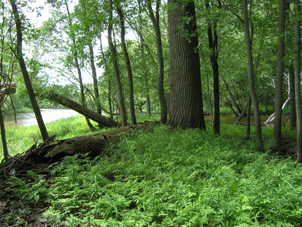
Overview
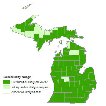
Floodplain forest is a bottomland, deciduous or deciduous-conifer forest community occupying low-lying areas adjacent to streams and rivers of third order or greater, and subject to periodic over-the-bank flooding and cycles of erosion and deposition. Species composition and community structure vary regionally and are influenced by flooding frequency and duration. Silver maple ( Acer saccharinum ) and green ash ( Fraxinus pennsylvanica ) are typically major overstory dominants. Floodplain forests occur along major rivers throughout the state, but are most extensive in the Lower Peninsula. Species richness is greatest in the southern Lower Peninsula, where many floodplain species reach the northern extent of their range.
County distribution
Landscape Context
Floodplain forests are located along streams and rivers of third order or greater. River floodplains occur within the four major physiographic systems (landforms) of Michigan: moraine, outwash plain, ice-contact terrain, and lakeplain. However, because the present drainage system is closely associated with drainage patterns that developed during the retreat of the Wisconsinan glaciers, river floodplains most frequently occur within former glacial meltwater (outwash) channels. River floodplains occur within broad outwash plains as well as narrow outwash plains situated between end moraines, and the river channels occasionally cut through moraines. In glacial lakeplains, large stretches of rivers flow through sand channels that formed where glacial meltwater carried and deposited sand into the proglacial lakes, but other stretches cut through fine silty and clayey lacustrine sediments.
Soils
Soil is highly variable and strongly correlated with fluvial landforms. The coarsest sediment is deposited on the natural levee, immediately adjacent to the stream channel, where the soil texture is often sandy loam to loam. Progressively finer soil particles are deposited with increasing distance from the stream. Soil texture of the first bottom is often silt loam, with silty clay loam to clay-textured soil often occurring in swales and backswamps. Cycles of periodic over-the-bank flooding followed by soil aeration when the floodwaters recede generally prevent the accumulation of organic soils. However, an accumulation of sapric peat can develop farther from the river due to a relatively low flood frequency, low flow velocity, and prolonged soil saturation resulting from a high water table. Floodplain soils are generally circumneutral to mildly alkaline. Slightly acid soils are generally only found on hummocks of organic soil in backswamps or meander-scar swamps. Floodplain soils are characterized by high nutrient availability and an abundance of soil water throughout much of the growing season.
Natural Processes
Direct interaction between terrestrial and aquatic ecosystems occurs in floodplain forests through the processes of over-the-bank flooding, bank cutting, and sedimentation. Over-the-bank flooding can directly cause treefall or indirectly lead to windthrow through increased soil saturation. Spring floodwaters often carry ice floes and debris that can scour trees, leading to the development of multiple-stemmed canopy trees. The input of organic matter from the floodplain forest provides sources of energy for aquatic organisms. Shade from streamside vegetation moderates temperature regimes in aquatic systems, preventing excessive warming of the river during summer months. Woody debris from floodplain vegetation influences the development of channel morphology and provides necessary habitat for many aquatic organisms. Riparian vegetation reduces overland water flow and sediment transport. Nutrient uptake by floodplain vegetation and denitrification by soil bacteria decrease terrestrial inputs of nutrients into aquatic systems. Such processes are especially important in landscapes dominated by agricultural or urban land cover, where nutrient input from upland ecosystems is typically high. The dynamic process of channel migration creates a diversity of landscape features in floodplains. Hydrogeomorphic processes such as over-the-bank flooding, transport and deposition of sediment, and erosive and abrasive water movement cause the floodplains of large rivers to exhibit a variety of fluvial landforms, each of which is associated with a particular kind of vegetation. Such fluvial landforms are distinguished by their size, shape, elevation, soil characteristics, and location in relation to the stream channel. Several of the most characteristic fluvial landforms are natural levee, first bottom, backswamp, oxbow, and terrace. A key series of relationships link the physiography of the river valley with that of the upland landscape. Basin size, topographic relief, and geologic parent material of the upland landscape determine river discharge, river grade, sediment load, and sediment type. These factors strongly influence the formation of fluvial landforms through the hydrogeomorphic processes of erosion, deposition, and channel migration. The size, shape, and diversity of fluvial landforms in a river floodplain and their spatial pattern are the result of the interaction between a river and the local landscape. Because physiographic systems are characterized by their topographic form and parent material, floodplains within different physiographic systems are characterized by differences in stream gradient, channel pattern, local hydrology, and fluvial landforms. When a river flows through a flat region, such as a broad outwash plain or a lakeplain, a wide, continuous floodplain develops. Within these wide floodplains, extensive lateral channel migration and the deposition of progressively finer-textured sediment with increasing distance from the river lead to the formation of a variety of fluvial landforms. With uniformly low topography and a relatively high water table, the broad first bottom of rivers within outwash plains and lakeplains is periodically inundated during the growing season. In contrast, both the higher topographic relief and finer-textured parent material of moraines encourage the development of narrow river valleys with more restricted floodplains and a reduced duration of flooding. The development of narrow valleys also occurs where rivers occupy narrow outwash channels situated between end moraines. The high topographic relief, relatively steep slope gradients, and fine-textured soil of morainal landscapes restrict lateral channel migration, resulting in narrow, sinuous floodplains that are frequently dissected by a series of higher terraces. The frequency of over-the-bank flooding in morainal landscapes is generally less than that in outwash plains and lakeplains. Instead, groundwater plays a stronger role, and constant soil saturation due to groundwater seepage often results in localized accumulations of organic soil.
Vegetation
As a result of the dynamic, local nature of natural disturbance along stream channels, a typical floodplain forest consists of many small patches of vegetation with different species composition, and successional stages often correlated with fluvial landforms. Within a single floodplain forest, vegetation changes along a gradient of flooding frequency and duration. In addition to local variation in species composition and structure within a site, there are major regional differences in species composition between floodplain forests in northern and southern Michigan. In both regions, dominant tree species nearly always include silver maple and green ash. Previously, American elm ( Ulmus americana ) was also a major dominant, but it has been largely eliminated from the canopy by Dutch elm disease. Numerous other species can be important, especially in the southernmost watersheds, resulting in complex patterns of species dominance. Characteristic ground flora in southern Michigan include wild ginger ( Asarum canadense ), wood nettle ( Laportea canadensis ), stinging nettle ( Urtica dioica ), green dragon ( Arisaema dracontium ), purple meadow rue ( Thalictrum dasycarpum ), bluejoint grass ( Calamagrostis canadensis ), Virginia wild rye ( Elymus virginicus ), false nettle ( Boehmeria cylindrica ), carrion flower ( Smilax ecirrata ), starry false Solomon's seal ( Maianthemum stellatum ), lizard's tail ( Saururus cernuus ), Gray's sedge ( Carex grayi ), Muskingum sedge ( C . muskingumensis ), wood reedgrass ( Cinna arundinacea ), southern blue flag ( Iris virginica ), clearweed ( Pilea pumila ), swamp buttercup ( Ranunculus hispidus ), golden ragwort ( Packera aurea ), ostrich fern ( Matteuccia struthiopteris ), sensitive fern ( Onoclea sensibilis ), jewelweed ( Impatiens capensis ), skunk cabbage ( Symplocarpus foetidus ), late goldenrod ( Solidago gigantea ), and fringed loosestrife ( Lysimachia ciliata ). Compared to southern Michigan floodplains, grasses and sedges account for a larger portion of the ground flora in floodplains of northern Michigan. Grasses and sedges common to both northern and southern floodplain forests include bluejoint grass, Virginia wild rye, cut grass ( Leersia oryzoides ), fowl manna grass ( Glyceria striata ), lake sedge ( Carex lacustris ), great bladder sedge ( C . intumescens ), hop sedge ( C . lupulina ), and fringed sedge ( C . crinita ). Fluvial landforms, defined by their size, shape, elevation, soil, and position in relation to the stream channel, exert a strong influence on the patterning of floodplain vegetation. New land deposits immediately adjacent to the stream channel are dominated by black willow ( Salix nigra ) and cottonwood ( Populus deltoides ). The natural levee is often dominated by silver maple and green ash, but a variety of additional tree species may also be common, including basswood ( Tilia americana ), swamp white oak ( Quercus bicolor ), bur oak ( Q . macrocarpa ), sycamore ( Platanus occidentalis ), hackberry ( Celtis occidentalis ), box elder ( Acer negundo ), and shagbark hickory ( Carya ovata ). The low frequency and short duration of flooding on the levee and second bottom result in dense cover of shrubs and small trees such as musclewood ( Carpinus caroliniana ), alternate-leaved dogwood ( Cornus alternifolia ), gray dogwood ( C . foemina ), prickly ash ( Zanthoxylum americanum ), redbud ( Cercis canadensis ), hawthorns ( Crataegus spp.), spicebush ( Lindera benzoin ), nannyberry ( Viburnum lentago ), elderberry ( Sambucus canadensis ), bladdernut ( Staphylea trifolia ), and choke cherry ( Prunus virginiana ). Adjacent to the levee, the first bottom flat is flooded more frequently and for a longer period, limiting the tree canopy to silver maple, green ash, and American elm. Shrubs are typically rare within the first bottom flat, but vines including riverbank grape ( Vitis riparia ), poison ivy ( Toxicodendron radicans ), Virginia creeper ( Parthenocissus quinquefolia ), and moonseed ( Menispermum canadense ) may be abundant. Small depressions and swales where tree canopy coverage is low are often dominated by buttonbush ( Cephalanthus occidentalis ). Second bottoms are typically dominated by the same tree species common to the levee but can also include bitternut hickory ( Carya cordiformis ), butternut ( Juglans cinerea ), black walnut ( J . nigra ), black maple ( Acer nigrum ), and white ash ( Fraxinus americana ). Shrubs may also be abundant on second bottoms. Areas where organic soil accumulates, such as groundwater seepages, backswamps, and meander-scar swamps are often dominated by black ash ( Fraxinus nigra ), yellow birch ( Betula alleghaniensis ), red maple ( Acer rubrum ), tamarack ( Larix laricina ), northern white-cedar ( Thuja occidentalis ), white pine ( Pinus strobus ), and hemlock ( Tsuga canadensis ), with conifer coverage especially high in the northern part of the state and often lacking in southern Lower Michigan. Species such as royal fern ( Osmunda regalis ), dwarf raspberry ( Rubus pubescens ), and New York fern ( Thelypteris noveboracensis ) are often abundant in the ground cover of these fluvial landforms. Low terraces, within the floodplain but above the influence of floodwaters, are often dominated by American beech ( Fagus grandifolia ) and sugar maple ( Acer saccharum ), often with black maple in the southern Lower Peninsula and hemlock in the northern Lower and Upper Peninsulas. Higher terraces are dominated by oak and hickory in the southern part of the state, and oak and pine in the north.
Biodiversity Management Considerations
Successful conservation and management of floodplain forests can contribute significantly to regional biodiversity because these systems possess an unusually high diversity of plant and animal species, vegetation types, and ecological processes. By providing necessary hibernacula, breeding sites, foraging areas, and travel corridors, floodplain forests often support a high diversity of birds, herptiles, and mammals. Wider and more contiguous riparian systems support high levels of native plant species diversity compared to narrow, fragmented riparian systems. Riparian corridors may harbor twice the number of species than that found in adjacent upland areas. Conservation and management of floodplain forests require an ecosystem management perspective because of the complex longitudinal, lateral, and vertical dimensions of river systems. It is crucial to maintain the connectivity and longitudinal environmental gradients from headwater streams to the broad floodplains located downstream. The natural spatial and temporal patterns of stream flow rates, water levels, and run-off patterns must be maintained or reestablished, where feasible, because these hydrologic processes create the diverse structure that characterizes floodplain forests. Maintaining vegetated buffers in the uplands bordering floodplain forests will help improve stream water quality. Restoration of channel morphology may be important in areas where stream channelization, channel constriction, and dams have altered water delivery and geomorphology. Conservation and restoration of fragmented floodplain forests also requires active long-term management to maintain deer at low densities. Floodplain forests are highly susceptible to invasions by non-native species. Because of their linear shape and location between aquatic and terrestrial environments, floodplain forests have a high ratio of edge to interior habitat that may facilitate the movement of opportunistic species. Rivers and streams provide a route of transport that facilitates the spread of species across the landscape. Floodplain forests are highly and frequently disturbed systems that contain extensive areas of exposed mineral soil with high nutrient availability, characteristics that facilitate invasion by non-native species. Preemptive measures to minimize impacts of invasive species include maintaining mature floodplain forest, minimizing and eliminating trails and roads through floodplains, and buffering riparian areas with mature, continuous uplands. Once invasive species become established, control (through manual removal) becomes costly and intensive. Thus, monitoring and control efforts to detect and remove invasive species are critical to the long-term viability of floodplain forest. Some of the many invasive species that threaten the diversity and community structure of floodplains forests include garlic mustard ( Alliaria petiolata ), Dame's rocket ( Hesperis matronalis ), moneywort ( Lysimachia nummularia ), ground ivy ( Glechoma hederacea ), purple loosestrife ( Lythrum salicaria ), narrow-leaved cat-tail ( Typha angustifolia ), hybrid cat-tail ( Typha x glauca ), reed ( Phragmites australis subsp. australis ), reed canary grass ( Phalaris arundinacea ), European marsh thistle ( Cirsium palustre ), glossy buckthorn ( Frangula alnus ), common buckthorn ( R . cathartica ), Eurasian honeysuckles ( Lonicera morrowii , L . japonica , L . maackii , L . tatarica , L . x bella , and L . xylosteum ), Oriental bittersweet ( Celastrus orbiculatus ), Japanese barberry ( Berberis thunbergii ), multiflora rose ( Rosa multiflora ), autumn olive ( Elaeagnus umbellata ), common privet ( Ligustrum vulgare ), white mulberry ( Morus alba ), and Norway maple ( Acer platanoides ). In addition to non-native plant species, non-native pathogens and insects have profoundly altered floodplain forests (e.g., Dutch elm disease and the emerald ash borer). Throughout North America, almost all large rivers and their floodplains are subject to multiple hydrologic alterations, such as human-made levees, impoundments, channelization, dams, and changes in land use. By changing the flow of water, such hydrologic alterations interrupt flood pulses, which are critical in the dynamics of seed dispersal, plant establishment, nutrient cycling, channel scouring, sediment deposition, and the maintenance of species richness. Changes in land cover surrounding the floodplain have also altered species composition and structure within floodplain forests. Agricultural land cover in the adjacent uplands often leads to high-nutrient runoff entering the floodplain and stream, which lowers stream water quality. The abundance of impervious surface in urban landscapes often results in a flashy discharge into nearby rivers and degrades water quality.
Variation
Shifts in species composition occur gradually along a gradient from south to north, and to a lesser extent from lake-moderated areas along the coast to the interior of the state. Species richness is greatest in floodplains of the southern Lower Peninsula, where a number of species reach their northern extent. Conifers are typically absent from floodplains in the southern Lower Peninsula, though they may occur in groundwater seepages and meander-scar swamps, where organic soils accumulate. In northern Michigan, conifers often dominate backswamps, meander-scar swamps, and groundwater seepages. Compared to southern Michigan floodplains, grasses and sedges account for a larger portion of the ground flora in floodplains of northern Michigan. Floodplains within outwash plains and lakeplains are typically broader and more continuous than floodplains in morainal landscapes. When a river flows through a broad outwash plain or a lakeplain, the low topographic gradient and high sand content of the bank promotes the development of broad first bottoms, where extensive channel migration leads to the formation of a variety of fluvial landforms, including natural levees, meander scrolls, oxbow lakes, backswamps, and meander-scar swamps. In contrast, when a river flows through a morainal landscape, the higher topographic relief, steeper slope gradients, and finer textured soil restrict channel migration, resulting in narrow floodplains that are often dissected by higher terraces. The frequency and duration of flooding are reduced, and the ridge and swale topography that characterizes first bottoms within outwash plains and lakeplains is usually lacking.
Associated plants
-
Graminoids
blue-joint Calamagrostis canadensis
-
Graminoids
sedges Carex crinita, grayi, hirtifolia, intumescens, lacustris, lupulina, muskingumensis, stricta, tuckermanii
-
Graminoids
wood reedgrass Cinna arundinacea
-
Graminoids
beak grass Diarrhena obovata
-
Graminoids
riverbank wild-rye Elymus riparius
-
Graminoids
Virginia wild-rye Elymus virginicus
-
Graminoids
fowl manna grass Glyceria striata
-
Graminoids
cut grass Leersia oryzoides
-
Graminoids
white grass Leersia virginica
-
Forbs
wild leeks Allium burdickii, tricoccum
-
Forbs
wild garlic Allium canadense
-
Forbs
green dragon Arisaema dracontium
-
Forbs
jack-in-the-pulpit Arisaema triphyllum
-
Forbs
wild ginger Asarum canadense
-
Forbs
false nettle Boehmeria cylindrica
-
Forbs
blue cohoshes Caulophyllum giganteum, thalictroides
-
Forbs
turtlehead Chelone glabra
-
Forbs
honewort Cryptotaenia canadensis
-
Forbs
flat-topped white aster Doellingeria umbellata
-
Forbs
white trout lily Erythronium albidum
-
Forbs
yellow trout lily Erythronium americanum
-
Forbs
green-stemmed joe-pye-weed Eutrochium purpureum
-
Forbs
false mermaid Floerkea proserpinacoides
-
Forbs
wild geranium Geranium maculatum Species guide available Wild Geranium
-
Forbs
white avens Geum canadense
-
Forbs
Jerusalem-artichoke Helianthus tuberosus
-
Forbs
cow-parsnip Heracleum maximum
-
Forbs
great waterleaf Hydrophyllum appendiculatum
-
Forbs
Canada waterleaf Hydrophyllum canadense
-
Forbs
Virginia waterleaf Hydrophyllum virginianum
-
Forbs
jewelweed Impatiens capensis
-
Forbs
southern blue flag Iris virginica
-
Forbs
wood nettle Laportea canadensis
-
Forbs
Michigan lily Lilium michiganense
-
Forbs
cardinal flower Lobelia cardinalis
-
Forbs
fringed loosestrife Lysimachia ciliata
-
Forbs
Virginia bluebells Mertensia virginica
-
Forbs
golden ragwort Packera aurea
-
Forbs
arrow-arum Peltandra virginica
-
Forbs
jumpseed Persicaria virginiana
-
Forbs
clearweed Pilea pumila
-
Forbs
Solomon-seal Polygonatum biflorum
-
Forbs
pickerel-weed Pontederia cordata
-
Forbs
swamp buttercup Ranunculus hispidus
-
Forbs
water dock Rumex verticillatus
-
Forbs
black snakeroots Sanicula marilandica, odorata
-
Forbs
lizard’s tail Saururus cernuus
-
Forbs
carrion flower Smilax ecirrata
-
Forbs
goldenrods Solidago
-
Forbs
side-flowering aster Symphyotrichum lateriflorum
-
Forbs
skunk-cabbage Symplocarpus foetidus
-
Forbs
wood-sage Teucrium canadense
-
Forbs
purple meadow-rue Thalictrum dasycarpum
-
Forbs
drooping trillium Trillium flexipes
-
Forbs
common trillium Trillium grandiflorum
-
Forbs
stinging nettle Urtica dioica
-
Forbs
violets Viola
-
Ferns
maidenhair fern Adiantum pedatum
-
Ferns
bulblet fern Cystopteris bulbifera
-
Ferns
wood ferns Dryopteris
-
Ferns
ostrich fern Matteuccia struthiopteris
-
Ferns
sensitive fern Onoclea sensibilis
-
Ferns
royal fern Osmunda regalis
-
Ferns
New York fern Thelypteris noveboracensis
-
Fern Allies
field horsetail Equisetum arvense
-
Woody Vines
American bittersweet Celastrus scandens
-
Woody Vines
wild yam Dioscorea villosa
-
Woody Vines
moonseed Menispermum canadense
-
Woody Vines
Virginia creeper Parthenocissus quinquefolia
-
Woody Vines
poison-ivy Toxicodendron radicans
-
Woody Vines
riverbank grape Vitis riparia
-
Shrubs
buttonbush Cephalanthus occidentalis
-
Shrubs
dogwoods Cornus
-
Shrubs
whorled loosestrife Decodon verticillatus
-
Shrubs
wahoo Euonymus atropurpurea
-
Shrubs
spicebush Lindera benzoin
-
Shrubs
choke cherry Prunus virginiana
-
Shrubs
sandbar willow Salix exigua
-
Shrubs
bladdernut Staphylea trifolia
-
Shrubs
black-haw Viburnum prunifolium
-
Shrubs
prickly ash Zanthoxylum americanum
-
Trees
box elder Acer negundo
-
Trees
black maple Acer nigrum
-
Trees
red maple Acer rubrum
-
Trees
silver maple Acer saccharinum
-
Trees
sugar maple Acer saccharum
-
Trees
pawpaw Asimina triloba
-
Trees
yellow birch Betula alleghaniensis
-
Trees
musclewood Carpinus caroliniana
-
Trees
bitternut hickory Carya cordiformis
-
Trees
shagbark hickory Carya ovata
-
Trees
hackberry Celtis occidentalis
-
Trees
redbud Cercis canadensis
-
Trees
hawthorns Crataegus
-
Trees
beech Fagus grandifolia
-
Trees
black ash Fraxinus nigra
-
Trees
green ash Fraxinus pennsylvanica
-
Trees
pumpkin ash Fraxinus profunda
-
Trees
blue ash Fraxinus quadrangulata
-
Trees
honey locust Gleditsia triacanthos
-
Trees
Kentucky coffee-tree Gymnocladus dioicus
-
Trees
butternut Juglans cinerea
-
Trees
black walnut Juglans nigra
-
Trees
red mulberry Morus rubra
-
Trees
white pine Pinus strobus
-
Trees
sycamore Platanus occidentalis
-
Trees
cottonwood Populus deltoides
-
Trees
swamp white oak Quercus bicolor
-
Trees
bur oak Quercus macrocarpa
-
Trees
red oak Quercus rubra
-
Trees
peach-leaf willow Salix amygdaloides
-
Trees
black willow Salix nigra
-
Trees
northern white-cedar Thuja occidentalis
-
Trees
basswood Tilia americana
-
Trees
hemlock Tsuga canadensis
-
Trees
American elm Ulmus americana
MNFI via Ecological Commons